Blazing a trail, or "This is a nice place"
This is a tale of a trail. the tale has a beginning and a middle, but is still waiting for an ending. I tell it to this point in the hope that its authors come up with a better ending than the one it looks like they're writing.
Once upon a time, I-85 was a four lane highway through north Durham. Recognizing that projected traffic volumes would overflow a road of that size, the NCDOT developed a plan to widen the highway to 4 (or 5, or 6, depending on the exact location) lanes in each direction through the urban part of town, roughly exits 173 through 178. A small neighborhood road called Brookline Drive ran just south of the highway at about mile marker 176. It was a little neighborhood shortcut between Acadia Street and Washington Street, and although a few people missed it when it went away as part of the widening project, it wasn't a major loss.
In fact, the NCDOT promised to convert Brookline to a walking trail between Duke Park on the East, and the South Ellerbe Creek trail, which has a trailhead at the intersection of Club Blvd. and Washington.
The trail isn't exactly finished, but it's opened, and i took a walk on it the other night.
Here's a bit of what i found.
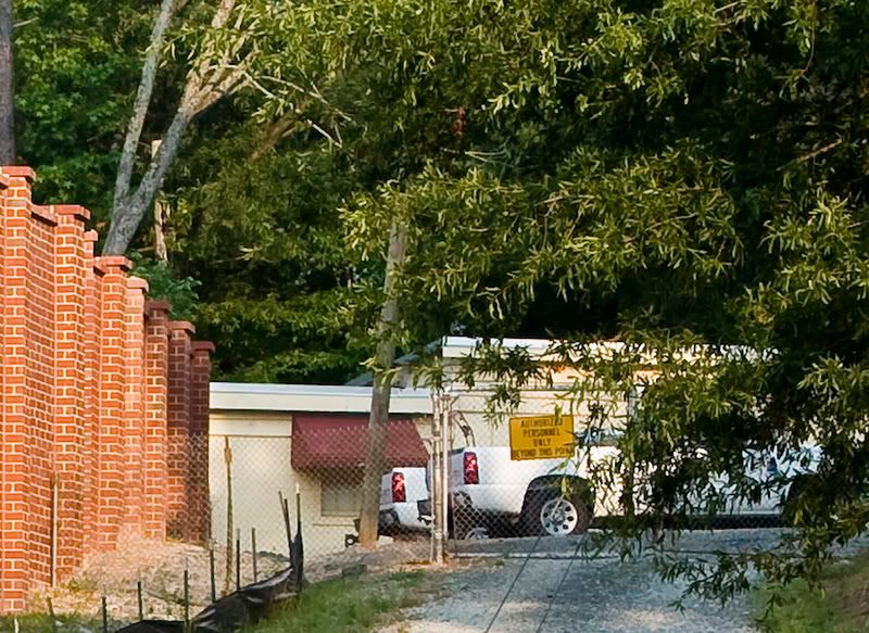
For starters, the trail doesn't extend into Duke Park, but actually terminates at the end of Acadia St. That's not necessarily a bad thing, but it really would be nice if there was a trailhead in the park. There's a lovely ravine at the east end of Duke Park which could, with a bit of imagination and money, be a small nature preserve. There's red-tail hawks nesting there, and some native flora that i'm not expert enough to identify. That would make a nice spur off the Ellerbe Trail.
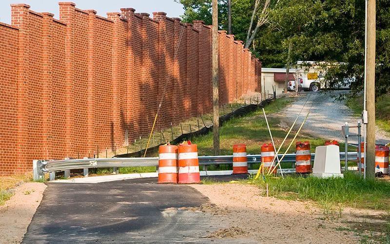
Down at the Acadia St. entrance, there's a few orange barrels, but no gate or bollard systm to prevent motor vehicles from entering the trail. It's possbile that those are set to be installed at some future date.
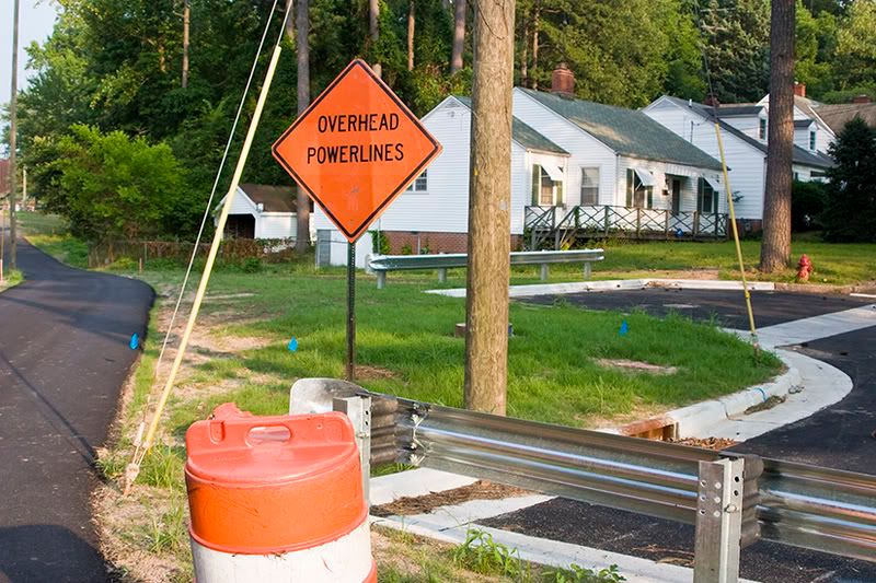
But after looking at the guard rail system that's been installed at the foot of Glendale (above), you have to wonder. The little turnout in the middle right of the photo really has nothing in place to prevent a car or pickup truck from driving over the curb onto the paved trail. And don't think that people won't be doing just that.
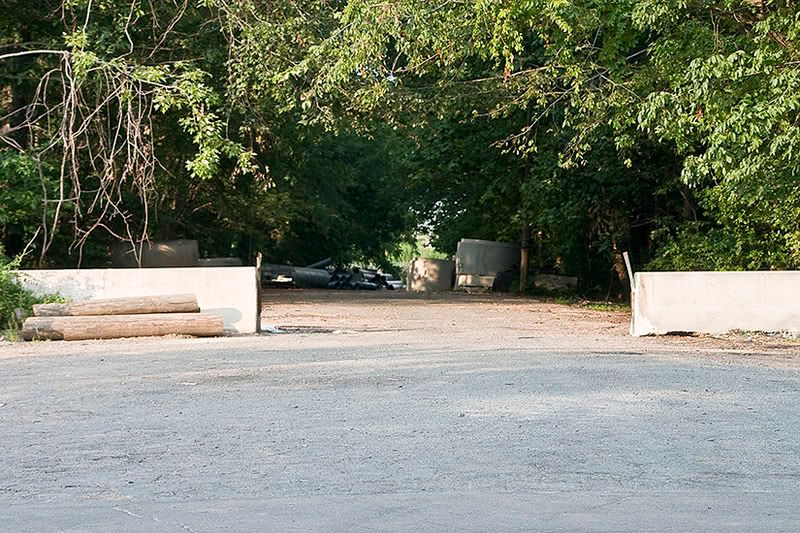
Things are no better at the Washington St. end of the trail, which is wide open to vehicles of any size. And given the recent headlines and listserv posts about thefts of storm drain gratings and manhole covers, that's a pretty big oversight.

There's some other problems with the Washington St. terminus of the new trail. It too, doesn't really connect with anything. The trailhead for the South Ellerbe Creek trail is on the other side of Washington, about 100 or so yards north. Which means you've either got to dash across Washington where you come out of the trail, or head north on the shoulderless and sidewalk free road itself. Washington, as those of you who drive on it or live near it know, is absurdly wide for a two lane road, nearly 55 feet across. Northbound traffic is coming around a blind curve if you're thinking of crossing there. Southbound traffic has often accelerated to make the light at Club, and seeing cars go by at 50 mph or so is not uncommon. There's a patch of woods north of the old Brookline right of way that the trail could still be constructed on, which would put you much closer to the Ellerbe Creek trail, and let you cross Washington at the signalized intersection without having to walk unprotected on the road.

On the trail itself, there are some more issues. The sound wall does a surprisingly good job of minimizing traffic noise. But it's construction has created some potential erosion problems which it doesn't look like NCDOT's planting program is going to solve. Look for washouts behind the concrete retaining wall, and especially in the area where the retaining wall ends.
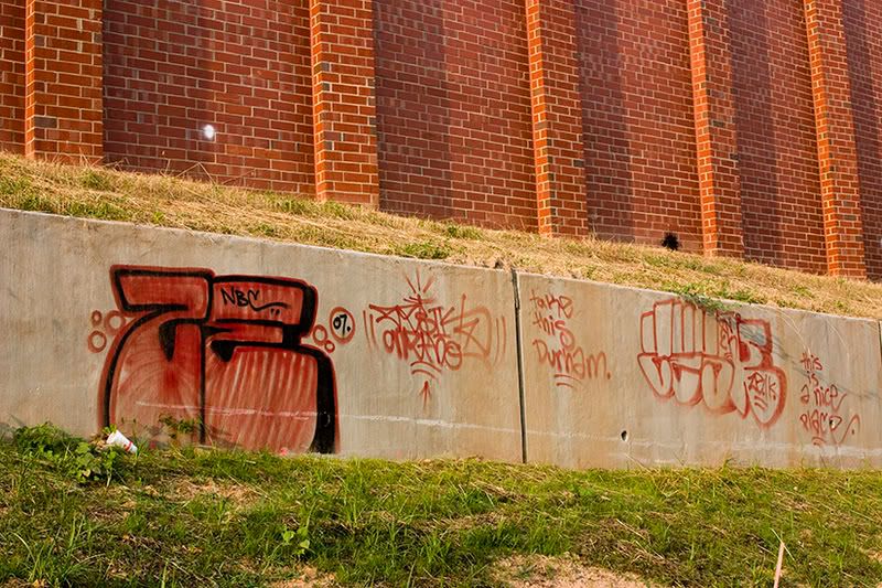
And speaking of the retaining wall, well, what do you expect when you put a blank canvas up in such an out of the way, yet easily accessible place? It's taken multiple phone calls to the city this week to explain exactly where this graffiti is located, and to determine who has jurisdiction over cleaning it up. the area is still, to my knowledge, NCDOT right of way. It may actually make sense in the long term to call it a freedom of expression zone, and encourage the creation of art, because otherwise, the city is going to be cleaning up graffiti at this location on a pretty regular basis.
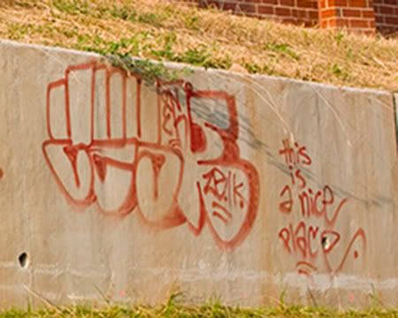
As the sign says, this is a nice place.
UPDATE: Graffiti had been removed by end of day Friday.
Once upon a time, I-85 was a four lane highway through north Durham. Recognizing that projected traffic volumes would overflow a road of that size, the NCDOT developed a plan to widen the highway to 4 (or 5, or 6, depending on the exact location) lanes in each direction through the urban part of town, roughly exits 173 through 178. A small neighborhood road called Brookline Drive ran just south of the highway at about mile marker 176. It was a little neighborhood shortcut between Acadia Street and Washington Street, and although a few people missed it when it went away as part of the widening project, it wasn't a major loss.
In fact, the NCDOT promised to convert Brookline to a walking trail between Duke Park on the East, and the South Ellerbe Creek trail, which has a trailhead at the intersection of Club Blvd. and Washington.
The trail isn't exactly finished, but it's opened, and i took a walk on it the other night.
Here's a bit of what i found.

For starters, the trail doesn't extend into Duke Park, but actually terminates at the end of Acadia St. That's not necessarily a bad thing, but it really would be nice if there was a trailhead in the park. There's a lovely ravine at the east end of Duke Park which could, with a bit of imagination and money, be a small nature preserve. There's red-tail hawks nesting there, and some native flora that i'm not expert enough to identify. That would make a nice spur off the Ellerbe Trail.

Down at the Acadia St. entrance, there's a few orange barrels, but no gate or bollard systm to prevent motor vehicles from entering the trail. It's possbile that those are set to be installed at some future date.

But after looking at the guard rail system that's been installed at the foot of Glendale (above), you have to wonder. The little turnout in the middle right of the photo really has nothing in place to prevent a car or pickup truck from driving over the curb onto the paved trail. And don't think that people won't be doing just that.

Things are no better at the Washington St. end of the trail, which is wide open to vehicles of any size. And given the recent headlines and listserv posts about thefts of storm drain gratings and manhole covers, that's a pretty big oversight.

There's some other problems with the Washington St. terminus of the new trail. It too, doesn't really connect with anything. The trailhead for the South Ellerbe Creek trail is on the other side of Washington, about 100 or so yards north. Which means you've either got to dash across Washington where you come out of the trail, or head north on the shoulderless and sidewalk free road itself. Washington, as those of you who drive on it or live near it know, is absurdly wide for a two lane road, nearly 55 feet across. Northbound traffic is coming around a blind curve if you're thinking of crossing there. Southbound traffic has often accelerated to make the light at Club, and seeing cars go by at 50 mph or so is not uncommon. There's a patch of woods north of the old Brookline right of way that the trail could still be constructed on, which would put you much closer to the Ellerbe Creek trail, and let you cross Washington at the signalized intersection without having to walk unprotected on the road.

On the trail itself, there are some more issues. The sound wall does a surprisingly good job of minimizing traffic noise. But it's construction has created some potential erosion problems which it doesn't look like NCDOT's planting program is going to solve. Look for washouts behind the concrete retaining wall, and especially in the area where the retaining wall ends.

And speaking of the retaining wall, well, what do you expect when you put a blank canvas up in such an out of the way, yet easily accessible place? It's taken multiple phone calls to the city this week to explain exactly where this graffiti is located, and to determine who has jurisdiction over cleaning it up. the area is still, to my knowledge, NCDOT right of way. It may actually make sense in the long term to call it a freedom of expression zone, and encourage the creation of art, because otherwise, the city is going to be cleaning up graffiti at this location on a pretty regular basis.

As the sign says, this is a nice place.
UPDATE: Graffiti had been removed by end of day Friday.

 Since 1949, Durhamites have slept soundly, secure in the knowledge that, in our town, erection can be depended upon. Now, thanks to the power of the internets, we can spread that security all over the world.

4 Comments:
Ahh, but some tagger has added more at the Acadia terminus.
Worth a picture.
By Anonymous, at 9:13 AM
I have a story about some new graffiti there, airing tonight at 5:30, Barry.
Anthony Wilson
ABC11 Eyewitness News
By ADub, at 2:42 PM
There's also some that appears to be gang related on the other side of the wall (freeway side) at the Washington St. overpass, at least as of 3/22.
By Barry, at 2:47 PM
Here's a chance to put your money where your mouth is: NC MST Falls Lake Workday. We have very few Durmites turn out.
By Anonymous, at 5:42 PM
Post a Comment
<< Home